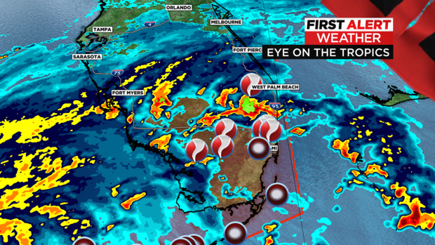
As of 11 p.m. Tuesday, Hurricane Ian is lashing much of southern Florida, with a Tornado Watch in effect until Wednesday morning. Multiple reports, as well as radar, indicated funnel clouds have been seen.
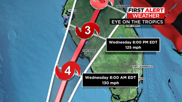
Winds are currently 120 mph, holding Ian steady as a Category 3. It’s moving at 10 mph north. It’s a healthy storm with large eye about 33 miles in diameter. In addition to tornado watches, flood alerts have been popping up all day. The models are indicating possibly becoming a Category 4 before landfall, due to the slow progression.
It will now likely make landfall in Fort Meyers between Sarasota to Naples on Wednesday afternoon.
CBS2
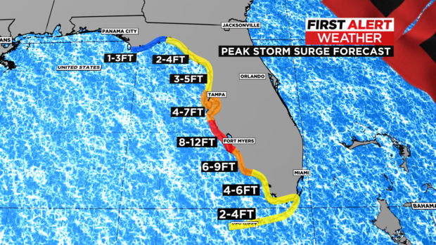
Regarding storm surge, numbers are up a little from yesterday, now showing 8-12 feet at its peak from just south of Tampa Bay, down to Bonita Beach.
CBS2
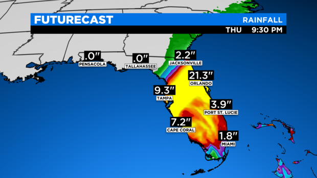
Potentially huge rainfall numbers could be seen through northern central Florida, with 1-2 feet of rain on the table for some areas.
CBS2
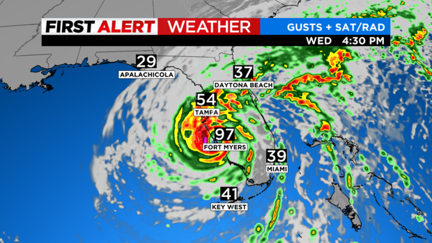
Hurricane force winds over 74 mph are likely to start hitting land Wednesday morning and could last through much of the day. The storm is slowing down a bit, allowing for multiple high tide cycles to occur. This is what will prolong any surge or inundation and really elevate the dangers. As the eyewall breaches the beaches Wednesday afternoon, peak winds will occur.
CBS2
Tornadoes have spawned south of West Palm, with lines of thunderstorms through much of Tuesday. The heavy rain will pivot north, currently eyeing Orlando right now as a rainfall bullseye. Miami will see fringe effects of the storm with 1-3 inches of additional rain and gusts to 40 mph.
CBS2
All of this subject to shift some regarding track and possibly intensity, but nothing is stopping this monster from ruinous effects in Florida.
Stay connected with us on social media platform for instant update click here to join our Twitter, & Facebook
We are now on Telegram. Click here to join our channel (@TechiUpdate) and stay updated with the latest Technology headlines.
For all the latest Entertainment News Click Here