
Sunny Southern California has not been so sunny lately, with gray skies casting a dreary shroud over the region.
What causes the stubborn low clouds that muscle out the sunshine day after day?
To start with, the cloud cover is a function of the season. In May and June, the upper atmosphere is more stagnant. Troughs of low pressure, the kind that brings rain in winter, still pass over the region but are much weaker. At the same time, the sun’s angle is higher and more direct. It heats the land and air, but the ocean remains cool, because water absorbs heat.
Ocean surface temperatures off Southern California were below average earlier in May but now are near normal, in the low- to mid-60s, said Alex Tardy, a meteorologist with the National Weather Service in San Diego. That’s cool enough for the water to chill the layer of air directly above it.
Normally, air temperature gets cooler as it gets higher in the atmosphere. But because of the chilling effect of the ocean, the layer of air near the water’s surface is cooler than the layer immediately above it. Above that cooler layer, the air abruptly warms before cooling higher in the atmosphere. The warmer layer is called an “inversion” — in this case, a marine inversion — and the cool air trapped beneath it is the marine layer.

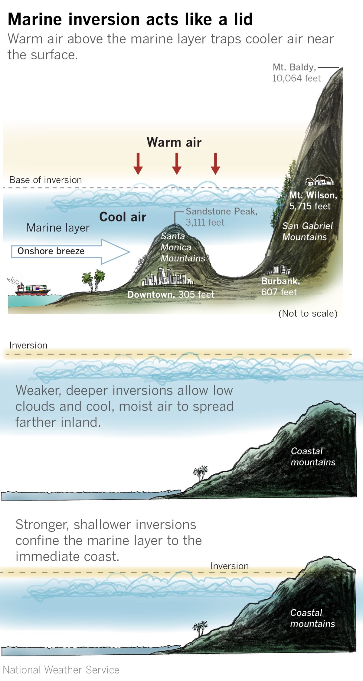
(Paul Duginski / Los Angeles Times)
The marine inversion acts as a lid, controlling the marine layer vertically. Surface winds or breezes, which tend to blow onshore because of the difference in temperature between water and land, move the marine layer clouds horizontally. Geographic features such as coastal mountains and hills can be obstacles for the layer, depending on the depth of the inversion, and can help to corral the low clouds at the coast. If the lid is set higher, low clouds can jump the coastal geography and spread far inland to where they bump up against the coast-facing slopes of much higher mountains, such as the San Gabriels.
The Southland’s deep marine layer during the last few days has been the result of onshore flow and upper-level low pressure. Such a trough of low pressure is an area of rising air in the atmosphere above the marine inversion. The decreased air pressure above the inversion lid allows the inversion to rise and deepen. If the inversion rises and weakens too much, it dissipates; then the marine layer is broken up, and the gray skies clear. With the lid set at an altitude of about 5,000 feet, the low clouds can spread farther inland to the Inland Empire and Cajon and San Gorgonio passes.


Low clouds extend far inland in this satellite photo of the Southern California coast taken Tuesday at 9 a.m.
(NOAA / Los Angeles Times)
As high pressure, or ridging, builds later this week, the inversion is expected to be squashed down, making the marine layer shallower. Under these conditions, the clouds are not able to penetrate as far inland. That’s because high-pressure air is sinking, pressing down on the air and the inversion beneath it. This fortifies the inversion as it squeezes downward on the marine layer. When the inversion is shallow enough — down to 500 feet or so — the marine layer is confined to the coast. At that point, the clouds are squeezed down and are in contact with the land’s surface, forming the kind of beach fog that can seem as thick as pea soup, but leaving sunny skies just a few miles inland. Sometimes in these conditions, the sun breaks through just blocks from the beach.
As Tardy points out, the weather pattern that brought heat to the Southland and monsoon-like thunderstorms to mountains and deserts May 10-22 featured high pressure at upper levels of the atmosphere. This upper-level ridging compressed the marine inversion, confining the marine layer clouds and fog to the immediate coast.


Prevailing northwesterly winds can set up an eddy circulation as they round Point Conception.
(Paul Duginski / Los Angeles Times)
Another mechanism that can spin low clouds inland in Southern California is the Catalina, or coastal, eddy. This is the counterclockwise circulation of air that develops when the prevailing northwesterly winds swirl around Point Conception. It is often centered near Santa Catalina Island, from which it gets its name. These eddies behave like small low-pressure centers and mainly occur from April to September, peaking in June.
A weak trough of low pressure moving across Southern California on Tuesday provides hope of clearing skies as it makes the marine layer more unstable, said Tardy.
“These weak Pacific storms are good — though we suffer for a couple of days in thick, deep marine layer — as they will mix out and partially clear out the marine clouds,” he said.
But as May draws to a close, Southern Californians aren’t out of the woods. We potentially face a full month of June gloom, another weather condition that may keep the region under gray skies.
Stay connected with us on social media platform for instant update click here to join our Twitter, & Facebook
We are now on Telegram. Click here to join our channel (@TechiUpdate) and stay updated with the latest Technology headlines.
For all the latest Fashion News Click Here